The Federal Emergency Management Agency (FEMA) has identified Special Flood Hazard Areas within the boundaries of Calvert County. Special Flood Hazard Areas (SFHAs) face a risk of flooding from the 1% annual chance flood, this is referred to as base flood.
Calvert County participates in a federal insurance program, the Community Rating System (CRS) program, that offers reduced flood insurance rates in turn for stronger protections from flood hazards. Calvert County does this through zoning regulations and public education. Zoning regulations for floodplain areas in Calvert County are located in the Calvert County Zoning Ordinance, Section 24. Calvert’s current CRS score is 8, earning a 10% reduction in flood insurance premiums.
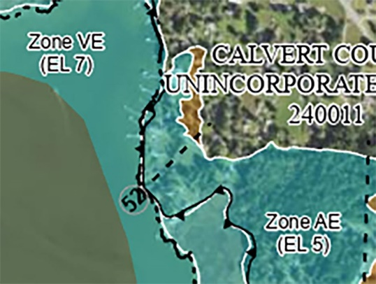
FEMA periodically updates Flood Insurance Rate Maps (FIRM). Calvert’s were last updated in 2013 and delineate Calvert County into different flood-risk zones, including the Special Flood Hazard Area. Calvert County also provides FEMA flood hazard maps.
Special Flood Hazard Areas/Flood Insurance Rate Map
The map shown is from a federal FIRM and depicts Special Flood Hazard Areas (SFHAs) with base flood elevations (e.g. EL 7). SFHAs include Zones A, AE, AH, AO, AR, A99, V and VE. Property within the SFHA must follow floodplain regulations to be eligible for NFIP benefits—permits are required for all development activity in the SFHA!
Find a glossary of terms through the Association of State Floodplain Managers.
Development in the Floodplain
All development in a SFHA requires a permit. Additional documents may be required if you’re building a new structure or improving your existing structure greater than 50% of its fair market value:
Download MyCoast Maryland to report flooding! The next time you see flooding, submit a picture on the MyCoast Maryland app. Your reports help us collect flood data and direct emergency response vehicles. MyCoast is a statewide database. You can also upload photos of floods from historical events to help us develop flood trends .
Do not walk through flood waters. Currents are deceptive; 6 inches of moving water can knock you off your feet. If you must walk, use a stick to ensure the ground is still there.
Do not drive through a flooded area. More people drown in their cars than anywhere else. Do not drive around barriers, as the road or bridge may be washed out.
Stay away from power lines and electrical wires. The number two flood killer after drowning is electrocution. Report downed power lines to the power company or 911. Turn off all electrical circuits and gas lines that may come in contact with flood water.
Don’t wait for the next flood ‒ there is a 30 day waiting period for coverage to take effect. To find out more about flood insurance, contact any licensed insurance agent.
Always check with the Building Department before you build on, alter, degrade or fill on your property. A permit may be needed to ensure that a project is compliant with all regulations.
Do not walk through flood waters. Currents are deceptive ‒ six inches of moving water can knock you off your feet.
Don’t pour oil, grease, pesticides, or other pollutants down storm drains or into the ditches and streams. Our streams and wetlands help moderate flooding and are habitat for fish, frogs, and other species that provide us with recreation or food. Let’s protect them and their homes.
 MyCoast App Report Flooding